


What it looks like today.
Please Subscribe to our Backup Platform. https://www.patreon.com/BPEarthWatch
Here are some cool sites with model info.
https://www.ventusky.com/?p=39.8;-79.5;3&l=wind&t=20170911/18
https://www.windy.com/?2017-09-11-18,40.816,-73.118,5
https://www.tropicaltidbits.com/analysis/models/
Go to the hurricane models and see what they have.
http://weather.gc.ca/hurricane/track_e.html
Remarks: At this point it looks like FLORIDA, but then some of the models have it on the east coast and then coming north. I saw a model Sunday, the one that had Wilmington as the point of impact, but after that it had it going to Washinngton, DC, so anything is possible. I remember when Hurricane Floyd was coming up here and they said there was no way it wouldn't, and then, it didn't. Same with Isabel. God can control and stop anything and steer it someplace else. Just pay attention, check on the models, get yourself a notebook, and start thinking strategically if you have to evacuate.
Strategic Thinking:
What do I need to take with me?
Make a list. Look at the stuff you use in your home now, in the morning, afternoon, evening, that's stuff you need.
Where can I go and how long do I need to be there?
What things will I need when I get someplace else, where are these places located? (banks, drug stores, food housing), get some paper maps in case the GPS goes down.
Be cognizant if your area is destroyed and uninhabitable after the storm, you need clothes etc. Try to take some totes with you, if you have an extra day or two, check out storage units in other locations and try to move some of your stuff in case you cannot come back.
Also get some coolers, ice packs stick them in your freezer now, get some tupperware, make yourself some stuff to eat before you leave, get ice from the local convenience store, there may be traffic jams. Take plastic bags (supermarket fruit/vegetable) with twist ties. You will have to put your garbage someplace so you don't attract bugs if there are no garbage cans along your journey. Take some toilet paper and paper towels, large garbage bags. Try to have a small shovel IF you end up having to use the woods as bathroom facilities, you have to bury that stuff 5 feet deep and preferably 16 feet from whereever you may have to camp out to prevent it from contaminating water sources. Yes get a tarp, take a camp chair with you, and some basic camping equipment just in case. Get a small hand held water purifier in case you have to camp in the woods. Devastation is different than let's just go to somebody's house for a few days. Think the best, prepare for the worst.
Portable device chargers, charged up. You need that.
Have you looked at a service provider map to see if your phone carrier has service in the areas you may need to evacuate to? Here in NY, if you go upstate only Tracfone works, the others don't.
Just make your list(s), and make a plan.
[Edited on 9/5/2017 by gina]
While the storm’s exact path is unclear, the Capital Weather Gang’s meteorologists issued similarly unnerving warnings of Irma being “likely to make landfall somewhere in Florida over the weekend” and saying that “the impact could be catastrophic.”
Scott has activated 100 members of the Florida National Guard and said he had directed all 7,000 members to report for duty on Friday. On Monday, Scott signed an executive order declaring an emergency in each of Florida’s 67 counties, pointing to forecasts at the time warning that Irma could make landfall in the southern or southwestern parts of the state and “travel up the entire spine of Florida.”
“Hurricane Irma is a major and life-threatening storm and Florida must be prepared,” Scott said in a statement accompanying the order.
Bernie explains the trough, which will determine west coast of FL, or east coast FL and North Carolina.


https://www.wunderground.com/cat6/category-5-irma-5th-strongest-atlantic-hurricane-record
180 mile per hour winds this morning.
https://twitter.com/hurrtrackerapp/status/905173556534837249/photo/1?ref_src ="twsrc%5Etfw&ref_url=http%3A%2F%2Fspaghettimodels.com%2F"
[Edited on 9/5/2017 by gina]
[Edited on 9/5/2017 by gina]
Joe Cioffi is saying that the European models have a slight inaccuracy which of course makes the difference in the track.
[Edited on 9/5/2017 by gina]
9-7-17
9-6 video from Anguilla and St. Maarten
https://www.rci.fm/infos/societe/les-ravages-dirma-en-video-et-photos
http://www.weatheroptics.net/top-stories/city-by-city-what-impacts-to-expect-from-dangerous-irma
Timing for Winds in Florida
https://www.wunderground.com/cat6/category-5-irma-hits-leeward-islands-peak-strength
http://www.nhc.noaa.gov/graphics_at1.shtml?cone#contents
http://www.nhc.noaa.gov/refresh/graphics_at1+shtml/215356.shtml?rainqpf#contents
Rain totals - bear this in mind if you are in Georgia and the Carolinas parts of the storm have 15-20 inches of rain in it. It has to dump that somewhere.
[Edited on 9/7/2017 by gina]
[Edited on 9/7/2017 by gina]
Some good advice to anyone stuck staying in Florida, there is no gas for the cars in some places to get out.
If you are in the FL keys and Can not evacuate, Call (305) 517-2480 to get help
https://twitter.com/hashtag/IrmaHurricane?src ="hash"
[Edited on 9/7/2017 by gina]
GEORGIA
Based on size of Hurricane #Irma + Category 4/5 landfall winds/surge & track up I-75 to Atlanta, are we contemplating a Trillion $ disaster?
Prior to that Miami is slated to be hit 72 hrs. from now with 910mbs.
https://www.tropicaltidbits.com/analysis/models/?model=hwrf®ion=11L&pkg=mslp_wind&runtime=2017090718&fh=54&xpos=0&ypos=150
http://weather.gc.ca/hurricane/track_e.html
Anybody along the Georgia coastline areas needs to get out now.
Impact Savannah 2 pm Monday. Cat 3 120 miles per hour.
https://twitter.com/JeffSmithABC7
There is still some difference in models. The European has Irma going thru the middle of Florida, while the GFS has it hit Miami then go out and go up along the coast till it comes in at Savannah.
[Edited on 9/7/2017 by gina]
RAINFALL MAP TOTALS FOR FLORIDA
8-12 INCHES FOR MIAMI, THE STORM HAS UP TO 24 INCHES OF RAIN IN IT.
 ?v=ap&w=1280&h=720&api=7db9fe61-7414-47b5-9871-e17d87b8b6a0
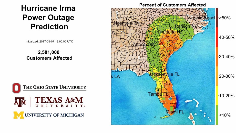
POWER OUTAGE ESTIMATES MAP
9-9-17 SAT
Most recent info. puts Tampa as the point of impact.
http://www.weatheroptics.net/tropical-discussion/irma-closes-in-on-florida
https://www.wunderground.com/cat6/cat-5-irma-churns-along-north-cuba-coas
?v=ap&w=1280&h=720&api=7db9fe61-7414-47b5-9871-e17d87b8b6a0Rainfall thru Tuesday
 ?v=ap&w=1280&h=720&api=7db9fe61-7414-47b5-9871-e17d87b8b6a0
Storm surge inundation map
http://www.nhc.noaa.gov/refresh/graphics_at1+shtml/154304.shtml?rainqpf#contents
The Florida Information Emergency Line is 1-800-342-3557. Lines are very busy, so please keep calling to get through!
Reuters Reporter, Producer in Miami, Justin Mitchell:
https://twitter.com/JstnMtchll
MSNBC - Andy Sullivan
https://twitter.com/andysullivan
https://twitter.com/alerttampa
FURTHER REMARKS: I don't want to tell you what I have seen on some of the modelling with Jose, how much is 250 knots? And there is another one after Jose. For now, prayers go out to Floridians, and Atlanta it will be coming your way after it is done with Florida. There were reports that Macon was already a big parking lot, so that may get worse since 6.5 million of the 20 million residents of Florida were now told to leave due to irma. 20 million residents, a 10 foot storm surge, 6.5 million told to evacuate.
Made landfall at marco island 3:30 pm Cat 3 Fox 4 news 11:30 mark the wind
These news media sources have good info.
WFLA Tampa
http://wfla.com/2017/09/10/watch-high-winds-and-rain-start-hitting-the-tampa-bay-area/
Remarks: It could have been worse, IF Irma hit Miami head on as was anticipated. So maybe the govt. did steer it away from the shorelines as much as possible. One other thing going on is that we may be in the beginning stages of the pole shift. Which will cause more intense storms to happen. Are you aware that there was a quake yesterday along the Juan de Fuca plate that caused the tectonic plate boundary to move 32 feet? Are you also aware that when the pole shift happens, and some say 9-23-17 is the date it is expected to, when the shift happens, the new pole will be off Brazil? That in and of itself will cause all kinds of weather changes. The press is not supposed to say 'climate change' anymore, they have some other catch phrase but all this stuff is going on.
Jose will become a powerful storm and it will be in the Atlantic potential strike date would be the 17th Carolina or NY IF it does not turn. There is still time on this one, but people along points North Carolina and north should begin considering what if they need to get out the way. I AM NOT SAYING IT IS GOING TO HIT EITHER OF THOSE TWO PLACES, JUST KEEP A LOOKOUT AND BE READY IN CASE....
[Edited on 9/10/2017 by gina]
[Edited on 9/10/2017 by gina]
RE: JOSE, one of the models has it coming pretty far north by 9-17-17 before heading out to sea. We will have to be on the lookout.
[Edited on 9/11/2017 by gina]
INUIT ELDERS NOTICE THE SUN IS NOT IN THE SAME PLACE IN THE SKY
The axis of the earth has changed. This in turn effects the weather due to the gravitational pulls, the geomagnetic grid etc. The people who noticed it back in 2015 were the Inuits who live along the Artic. What NASA did with the info. is not known. Each of the strong earthquakes we have changes the axis of the earth. I heard recently that the Mexico quake moved the Juan De Fuca tectonic plate 10 or 12 feet. The large quakes in previous years in Fukushima, Christchurch, New Zealand and Chile, also effected the axis of the earth, which effects the rotation etc. When the pole shift happens people are now saying the new pole will be in Brazil. Others say we may be in for a new ice age coming.
http://www.whitewolfpack.com/2015/04/earth-has-shifted-inuit-elders-issue.html
Moon not where it should be rotated to the right, or earth has rotated to the left. The Torah even said there would be changes in the moon and it gave the year which translates to 2011.
2-3-16
polar shift on the moon Jan 2011 (the music is awful turn your sound down)
UPDATE 9-13-17
There is someone who has figured out what happened. The poles have moved. The new north pole at this time is off of London, it is closest to Stonehenge. The new south pole is at New Zealand. The moon flipped on December 11, 2011, 1 1/2 hours later it had rotated 180 degrees. Antarctica shifted 90 degrees. The poles are not going to stay in these locations forever. Eventually the new North Pole will be in Russia and the new south pole will be in Cape Town, South Africa. When the land changes occur, the part of Africa that has Capetown in it, will move and shift going to the position that Antarctica is in now.
The thing is this, we are used to the equator being in the middle of our earth. The new equator will not be there. The magnetic grids of the planet will be changed. This has already effected airports where they have had to adjust where their landing strips are because the equipment the pilots fly by is no longer accurate to the runways, when they set the course for the plane, it has to adjust for these changes.
People keep talking about climate change noticing the weather changes, but it is not due to climate change like too much smog going up there influencing the weather. The problem is the tilt of the planet has changed, which means it does not face the sun the same way. The planet rotates on it's axis and it is now tilted differently. This effects the crops and food sources, it effects the ice in the arctic etc. which is melting. This melting ice changes the salinity of the oceans, which effects the storms including hurricanes because there is this symbiosis between the oceans and the sky/atmosphere.
Greenland experienced differences in their daylight and why the Inuits up there in the arctic are getting more hours of daylight. This is due to the tilt of the earth changing and putting us closer to the sun.
The tilt of our planet is now 92,000,000 miles from the sun. Previously it was 94.2 million miles. So now we are closer to the sun in certain places. North America, Europe, China, India, reportedly will become "unbearably hot" in the what is normally our winter time (January). Yes the climate will change, but it is due to the change in the axis, tilt of the earth, as well as the rotation.
The new north pole is currently located at North 51 degrees, 22.949 East, 12.922 degrees. It is located off Herne Bay, England at 23.4 degrees.
The new poles are temporary, it is still migrating. Nibiru has caused this.
Why is this happening? It is how God will destroy the peoples he said he would destroy. The heat will destroy the crops, famine, pestilence will occur, the heat will kill many and some people will freeze to death if they remain in areas that will no longer support life.
I will gather more info. to expand on this.
Axis shifts have happened before. Here is info. on one of them.
[Edited on 9/14/2017 by gina]
JOSE - it will not be doing anything that could be a threat to any land mass till late next week and it may not come in at all. it is complicated. Bernie understands all the possibilities and points out what is going on. I did see a model that had it just off the Jersey shore on Thurs. the 21st, but it is too early to say that is what will happen. If it did go in there, it would be in the same areas as Sandy, so we do need to check in on this storm.
JOSE - timing and locations and effects.
http://www.weatheroptics.net/top-stories/hurricane-jose-targets-southeastern-new-england
The storm is expected to track southeast of Long Island on Tuesday afternoon and southeastern New England by Tuesday night into Wednesday. Due to the influences discussed above, Jose will be a larger storm by the time it comes close to these areas, however the current forecast from WeatherOptics meteorologist keep the worst impacts off the coast at this time.
Expected to be a tropical storm by Tuesday, Jose will likely produce winds around 30 to 45 mph with gusts up to 60 mph along the immediate New Jersey, Long Island, Connecticut, Rhode Island, and southeastern Massachusetts coasts. Rainfall amounts will range from 2 to 3 inches around Nantucket, 1 to 2 inches over the rest of southeastern Massachusetts, and 0.5 to 1 inch of rain along the immediate New Jersey, Long Island, Connecticut, and Rhode Island coasts. Minor to moderate coastal flooding will also be a threat along the New Jersey coast up to southeastern Massachusetts, along with a very strong rip tide.
Remarks: As to the others up and coming, Maria and Lee,
Maria WEDNESDAY 2 p.m. PUERTO RICO CAT 4 130 miles per hour.
THURSDAY 2 p.m. DOMINICAN REPUBLIC CAT 2 up to 110 miles per hour.
I'm not going beyond that yet.
Update: Maria will NOT go thru Florida, it will turn and come up in the Atlantic and is not supposed to hit any land.
Update 9-21-17 After Maria is done gong thru the Carribean Islands and the Bahamas, it is believed that it will go out in the ocean and not strike any other land.
[Edited on 9/21/2017 by gina]
Mexico is facing another large quake, in the 6 range, according to an earthquake prediction specialist.
Okinawa and Guam may have quakes in the mid to high 4 ranges.
The Agean sea, and other areas also, even potentially Tennessee and Virginia in the 3-4's within 3-4 range.
Wednesday 9-27-17 a 65% increase in geomagnetic storms triggering earthquakes
Thursday 9-28-17 an 80% increase in geomagnetic storms.
Mount Agong, a 10,000 foot volcano in Bali erupting. Evacuations issued. Magma moving towards the surface.
Monaro Volcano in Vanuato Level 4
Ring of Fire earthquakes - Japan 5.6 Hokkaido
5.4 Tonga in Havelulob
Mexico continuing to wuake 4.3 in Oxaca in La Blanca
and Guerrero in Comitancillo and Tepantilian
5.3 in Indonesia Irian Jaya Barat Soray
QUAKE WATCH
9-28-17
7.1 possible between 9-28-17 and 9-30-17 for Mexico, same areas as hit recently.
Additionally, there is a system (storm/hurricane) that is expected to form near and go over Cuba. It can either go over Florida and come up the east coast, or go in the Gulf. What is eerie is that there was prophecy from 2015 which says that Houston will be destroyed by water, Los Angeles by earthquake.
Hurricane and Storm wise:
186 hours out from now: Southern Florida has a storm to deal with, that is expected to go up the east coast of Florida.
https://www.tropicaltidbits.com/analysis/models/?model=gfs®ion=us&pkg=mslp_pcpn_frzn&runtime=2017092918&fh=186&xpos=0&ypos=90
This is AL 9 - Gulf storm

You have two storms.
http://www.nhc.noaa.gov/
FLORIDA
Also, after the first week of October, more storms are expected to be coming off Africa.
[Edited on 9/29/2017 by gina]
Nibiru is Jupiter - the Sumerians (yes from the Bible) were from Jupiter.
Yes there will be another hurricane, will be named NATE, it is believed at this time to be heading to either into the Gulf near New Orleans, or near the Panhandle of Florida.
Impact Sunday 2 pm or thereabouts.
http://www.nhc.noaa.gov/refresh/graphics_at1+shtml/233944.shtml?cone#contents
I looked at the storm this morning, now the guestimates are that it will be more than a low range Cat 1.

More later, I am exhausted, but at least you got a little heads up.
[Edited on 10/5/2017 by gina]
10-5-17 THURSDAY
Apparently there is info. suggesting that the storm will reach CAT 4 status, yet most of the other weather people are STILL saying it would hit the Florida Panhandle as a Cat 1, 75 mph storm on Sunday, so I don't know what is going on.
What we know right now:
Nate made landfall over northeastern Nicaragua late Thursday morning as a tropical storm with 40 mph winds, and tropical storm warnings are up for much of the coast of Nicaragua and Honduras. However, the main danger to Central America from Nate will be torrential rains: 15 – 20” in Nicaragua, 5 – 10” in Panama and Costa Rica, and 4 - 8” in Honduras and the eastern Yucatan Peninsula. Much of the heavy rain in Nicaragua, Coast Rica, and Panama will occur on the Pacific side, as Nate’s large circulation pulls moisture from the Pacific across Central America and into the Southwest Caribbean. Satellite rainfall estimates show that the heaviest rains from Nate thus far have been on the Pacific side of Costa Rica and Panama, where over 8” of rain has fallen over the past 7 days.
Once Nate finishes its traverse of northeastern Honduras on Thursday evening and emerges into the Western Caribbean, the storm will be in a very favorable environment for intensification. Nate will be passing over an area of very high ocean heat content (OHC) in the Western Caribbean, with very warm waters that extend to great depth. Thursday SHIPS model Rapid Intensification Index gave Nate a 40% chance of being a Category 1 hurricane with 75 mph winds by 8 am Friday, 12 hours before it will make its closest pass to the Cozumel/Cancun area. The SHIPS model Rapid Intensification Index from 12Z Thursday morning showed a 48% chance of Nate gaining 65 knots of strength by Sunday, which would bring it to the Category 3 threshold (115 mph winds.)
By the time Nate reaches the United States, its quick movement will help limit the risk of extreme rainfall totals. A swath of 3 – 6” can be expected within about 150 miles of Nate’s center, from the Gulf Coast north across the Appalachians to parts of New York and/or New England.
Folks, it ain't looking so much like landfall for the Florida Panhandle.
GFS Run 60 hours out - Louisiana
As to why there is discrepancy among the models. The European thinks it would be the Florida Panhandle, but the GFS does not. It gets complicated because of troughs, windsheer etc. Levi did a very detailed video yesterday about the variables.
https://www.tropicaltidbits.com/
Ryan also thinks it looks more like New Orleans for this storm.
https://twitter.com/ryanmaue
EXPECTED IMPACT: NEW ORLEANS CAT 4

New Orleans
http://weather.gc.ca/hurricane/track_e.html
Cat 4 130 MILES PER HOUR
UPDATE FRIDAY
The meteorologists today have said they believe NATE will come onshore as a Cat 1 or weak Cat 2. The impact zone is still believed to be New Orleans.
This was Bernie's video from yesterday.
https://www.accuweather.com/en/videos/nate-to-approach-central-gulf-coast-late-saturday-night/f4bzi5yte6o0cnlleinxd2ssq527igk4
from 10-5-17
https://www.wunderground.com/cat6/hurricane-warnings-us-gulf-coast-ahead-strengthening-nate
Cat 1-2
A storm surge warning is up for the Gulf Coast from Morgan City, LA to the Alabama/Florida border, as well as along the northern and western shores of Lake Pontchartrain. In these areas, 4 – 7 feet of inundation were predicted by NHC in their 11 am EDT Friday advisory, assuming that Nate were to arrive during high tide.
https://twitter.com/JimCantore
I sure hope they don't make Jim Cantore stand out there in NATE to show people how bad it is. It's Yom Kippur, have mercy on him, I'm sure he is repentent.
Also, there is another system within 5 days there is a 70% chance of it forming into a storm in the Atlantic quite a bit North of Florida. Too soon to start speculating on that yet, just be aware it is there.
http://www.nhc.noaa.gov/gtwo.php?basin=atlc&fdays=5
Remarks: Why all these storms? Well it could be the folks who believe they will "own the weather" by 2025, or it could be God who told you in the Bible that men would faint from the roaring of the seas during the tribulation times. When I look these hurricanes, I look to see if it looks perfectly formed, those are the ones I think are from God, the ones that are perfectly symmetrical, the ones that confound the weather scientists who say the storms are not doing what they should be doing because God controls and does what he wants to. Bottom line is, the coastlines will be pummelled and hammerred if not by the 'we own the weather' people, then consider it God who is starting to unleash his punishments on an unrepentant nation.
[Edited on 10/7/2017 by gina]
NATE expected to be a CAT 2 when it strikes
Inundation map and how high they think the water will go. you can see the areas where more than 6 feet storm surge inundation is probable.
https://www.wunderground.com/cat6/hurricane-nate-still-strengthening-it-approaches-gulf-coast
[Edited on 10/7/2017 by gina]
ASTEROID COMING BY TONITE
Asteroids coming by increase the chance of earthquakes. Heads Up west coast!
Are we overreacting to the hurricanes? Nope.
Including Ophelia, there have been 15 tropical storms, 10 hurricanes and five major hurricanes so far in the 2017 Atlantic season, AND
"A strong tropical system centered a few hundred miles east of the Leeward Islands is being watched for possible development late in the upcoming weekend or early next week," Kottlowski said. Kottlowski anticipates that the only landmass that would see direct impacts from this system if it does develop would be Bermuda.
"I think there will be at least two more tropical storms, of which one or two can become a hurricane into December," Kottlowski said. "There is still a chance of one more major (Category 3) hurricane."
Remark: Hurricanes in December? Whippin post!